By Kevin Damasio


MANAUS, Brazil — It’s September, near the peak of 2023’s extreme drought in the Brazilian Amazon, and José Clodoaldo de Oliveira keeps an eye on the GPS as he pilots the voadeira, a small aluminum boat, in the Mariuá Archipelago along with two fellow researchers, while watching out for exposed sandbanks and rocks.
This is Earth’s largest fluvial island chain. It sprawls across 360 kilometers (220 miles) in the Middle Negro River, the Amazon River Basin’s second-largest tributary. Here, we find ourselves in a labyrinth of more than 1,400 islands, flooded forests, rivers, lakes and sandy beaches — with no signs of civilization in several stretches.
The Negro is a well-preserved backwater river chosen by scientists from the applied chemistry research group at Amazonas State University (UEA), to develop the Amazon Basin’s first water quality index (WQI) to evaluate water bodies’ state of health and guide public policies and scientific studies.
Near the shore in the Mariuá Archipelago, pink river dolphins swim up and down hunting for fish; a cayman glides toward a small strip of sand; capuchin monkeys leap from tree to tree; swarms of butterflies rest on a rock, peppering it white and yellow.
“The Negro is a beautiful river, but it also has its anthropogenic problems,” Oliveira, a 54-year-old geographer finishing his master’s degree in water resources, tells Mongabay. In the Middle Negro, he says, municipalities like Barcelos and Santa Isabel do Rio Negro discharge their untreated wastewater directly into the river. “So far, the Negro has been absorbing and handling all this waste, but for how long?”
In March, the UEA research team presented the results of their Negro River study. It identified 18 sites as being “excellent” according to the WQI standards, 30 as “good,” and two as “acceptable.” The average score of the 50 sample sites is 84 points out of a maximum 100. “The Negro River is very healthy,” says Sérgio Duvoisin Júnior, a physical chemist and head of the research group.
The highlight is the Mariuá Archipelago region when it comes to conservation. Here, the 26 sites analyzed had a mean score of 85, considered excellent, with seven spots rating above 90. There were similar results in the Anavilhanas Archipelago, the world’s second-largest fluvial island chain, protected as a national park. Along its 130 km (81 miles) in the Lower Negro River, it also had an average rating of 85 among the nine sites analyzed.
The scientists collected water samples at six locations upstream and downstream of three riverine municipalities. Despite the basic sanitation problems, the water quality remained the same going into and leaving Santa Isabel do Rio Negro and Novo Airão (83), while in Barcelos it increased from 83 to 92.
Extreme drought exposes more of the beach at Barcelos than normal in mid-September 2023. The drought was the result of an extreme climatic event that combined the warming of the waters of the Pacific, by El Niño, with the warming of the North Atlantic, intensified by climate change. Image by Bruno Kelly/Ambiental Media.
Of the two sites rated as “acceptable,” one was downstream of the confluence with the Branco River, the Negro’s largest tributary. The Branco is a whitewater river, with different characteristics, including a more alkaline pH, that lowered the WQI rating for that spot.
“The characteristics of the Branco are completely different from the Negro River. That’s why the rating was low, but it doesn’t mean it’s in a bad situation,” Duvoisin said.
The other “acceptable” site was on the Paraná do Cantagalo, a small branch of the Lower Negro River that had only decent results for pH level, electrical conductivity, dissolved oxygen and biological oxygen demand.
Overall, these were satisfying results for the UEA research group. “Every parameter was as expected. Even in the strongest drought, the river endured the struggle and maintained its characteristics. It really didn’t affect the water quality so much,” Duvoisin said.
During the September expedition, the Negro dried up at an average of 28.75 centimeters (11.32 inches) per day. On Oct. 26, the water reached a level of 12.7 meters (41.7 feet), the lowest recorded since measurements began in 1902. This was an extremely dry season resulting from a combination of warmer waters in both the equatorial Pacific, due to El Niño, and the tropical North Atlantic. Both phenomena were compounded by climate change.
Based on the data collected on the Negro River, the scientists were able to optimize the WQI for this type of water body. They defined that four of the nine parameters for a blackwater river should have equal weight in the index’s total value, or 15%: pH, dissolved oxygen, thermotolerant coliforms, and electrical conductivity — the latter substituting for water temperature, which shows little influence on water quality.
Electrical conductivity is an important indicator of pollution in the Amazon Basin, Duvoisin said. In blackwater rivers, the levels are very low because there are very few dissolved ions due to the natural lack of nutrients. The average score for conductivity was 9 microsiemens, while the maximum limit is 60.
In a healthy body of water like the Negro River, individual analysis of the physicochemical and microbiological parameters can identify locations that need more attention in terms of basic sanitation on stretches near municipalities and villages. Such monitoring can thus provide an early diagnosis to support public policy action at the beginning of the problem, allowing more effective and less costly solutions. “Now this knowledge should be used so that decision-makers in these small communities can begin taking preventive measures to keep it the way it is — to preserve something that is perfect,” Duvoisin said.
In August, the research team will present the index to the Amazonas state water resources council. If approved, this new WQI will be the official model for monitoring blackwater rivers in the state.

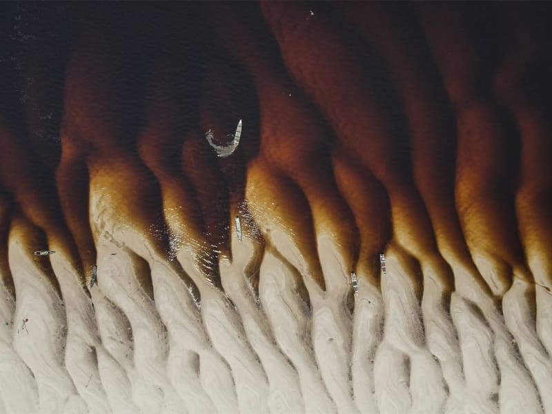
Exposed sandbanks in the Mariuá region speak to the intensity of the drought on the Negro River in mid-September 2023. Weeks later, the river would reach a record low of 12.7 meters (41.7 feet). Mariuá is the largest river archipelago in the world, with 1,400 islands spread over 360 kilometers in the Middle Negro River, between the mouths of the Urubaxi and Branco rivers. Image by Bruno Kelly/Ambiental Media.

The UEA research boat in Santa Isabel do Rio Negro, a municipality where 98% of the total land area is primary rainforest. Like other municipalities along the river, it lacks water treatment and basic sanitation, discharging untreated sewage directly into the river, at a sandy beach where fishermen dock to sell their fish. At the current scale, the river can still handle this waste, maintaining the same WQI rating of 83 in sampling sites upstream and downstream. Image by Bruno Kelly/Ambiental Media.
Understanding the river’s conservation
The UEA research group left Manaus, the Amazonas state capital, on Sept. 11 aboard an 18-m (60-ft) research vessel equipped with four laboratories and two voadeiras, for a 12-day journey up and down the Negro River. On board were 10 scientists: eight from UEA, to work on the WQI, and two from Harvard, who began a study on the mercury cycle in the Negro and the Madeira rivers.
The Negro’s main stream runs 2,250 km (1,400 miles) from its headwaters in Colombia until it merges with the Solimões, giving rise to the Amazon River. Along its course, it’s surrounded by riverine communities, protected areas and Indigenous territories.
“The water quality index needs to be based on places without human interference. In the Amazon, the Negro River fits this criterion,” Duvoisin says.
The WQI was created in the 1970s by the U.S.-based National Sanitation Foundation and diagnoses the state of a body of water by measuring nine physicochemical and microbiological parameters. Each water body is rated on a scale from 0 to 100, with a color-coded classification ranging from “very bad” to “excellent.”
Before the Negro River expedition, a specific WQI had never been developed for the Amazon Basin, the planet’s largest watershed. Water quality in the Amazon was measured using indexes tailored for waters in the southern states of São Paulo or Rio Grande do Sul, neither of which is part of the Amazon Basin, and whose rivers are more alkaline.

UEA researchers, from left, José Clodoaldo Oliveira, Douglas Siqueira and Gabriel Rodrigues search, with the help of a GPS, for a previously defined collection point in the Negro River in mid-September, 2023. Image by Bruno Kelly/Ambiental Media.
The Amazon Basin has blackwater, whitewater and clearwater rivers, requiring three different indexes. The UEA researchers plan to develop a WQI for each of the largest rivers in Amazonas state and maintain regular monitoring of these waters according to the seasonality.
Knowledge about Amazonian rivers is still being uncovered, according to Ane Alencar, director of science at the Amazon Environmental Research Institute (IPAM), who isn’t involved in the UEA program. Efficient remote sensing in the Amazon has already made it possible to identify changing patterns on water surfaces, she says, but there are limits to what we can understand on the ground about what this data really mean.
Alencar says the WQI, being a set of indicators, can better convey the problems faced by the Amazon Basin. “The extreme drought we have just faced and other issues such as mining have been affecting the rivers a lot, with important effects not only in the environment as a whole, but also in people’s lives,” Alencar says. “We need this data to understand the water quality.”
The WQI can also help improve planning for aquatic ecosystem studies on broad and local scales. Without this information, researchers have been “in the dark” as they go into the field where water quality is concerned, says biologist Cecília Gontijo Leal, a researcher at the University of Lancaster in the U.K. and at the Sustainable Amazon Network. “With a local reference, we can identify short-term or permanent impacts,” Leal, who isn’t involved in the UEA program, tells Mongabay.
Leal specializes in Amazonian freshwater ecosystems. While in the field, she always measures parameters like pH, water temperature and dissolved oxygen, but considers these data momentary. She says a proper index, one that addresses the ideal levels throughout the seasons, would bring more accuracy to such studies. “If we have this overview of the waters specifically related to its quality, we would be able to delve into subjects that we’re currently limited to.”
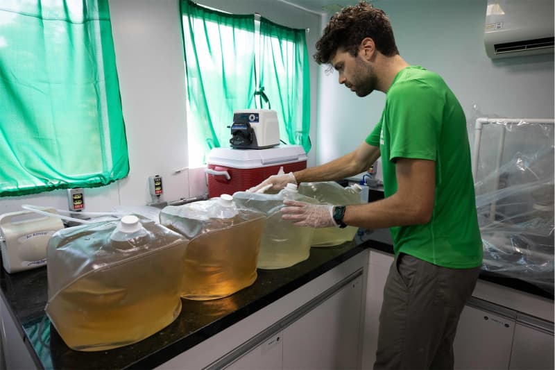
In a laboratory on board the boat, Evan Routhier organizes containers with water collected at parallel points of the Negro River: at the mouth of the Branco River, on the left bank, the waters are lighter; on the right bank of the Negro, without the influence of the whitewater river, the water is much darker. Image by Bruno Kelly/Ambiental Media.
A matter of public health
Four municipalities lie along the main course of the Negro River, with about 100,000 inhabitants in total, but these urbanized areas occupy just 0.1% of the Negro’s course.
Yet pressure on the river from urbanization is growing constantly, says biologist Adriano Nobre, the UEA expedition’s field and laboratory co-coordinator. He says it’s crucial to implement a monitoring system based on a proper WQI, not only for technical and scientific purposes but also to raise the local population’s awareness.
“Those who live by the river depend on the forest and the waters for extractivism, agriculture and fishing,” Nobre says. “Every kind of change or anomaly in an aquatic ecosystem will have a direct effect on their public health. Monitoring is important because we can identify any deviation in the water quality in the flooding, wet, ebb and dry seasons.”
“In the hinterlands, the state doesn’t pay attention to issues like the water supply network, sewerage, occupation,” said biologist Fernanda Vieira, 25, field and laboratory co-coordinator of the expedition. “We could see that the situation is very complicated.”
Basic sanitation (and its absence) has a major effect on the water index, whose main parameters are directly linked to sewage. The researchers say they hope their work will help decision-makers define relevant actions to recover a degraded body of water.
“In my city, the people don’t get water from the tap,” Josimar Sanches, a boat captain from Santa Isabel do Rio Negro, tells Mongabay. “Lots of them live close by the river, go there and pick it up in a bucket. They don’t even know the quality of that water.”
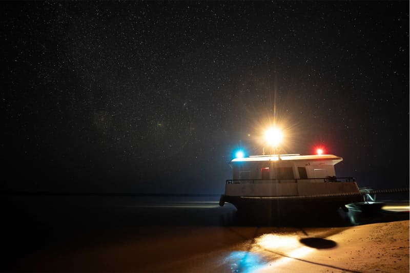
A research boat is seen docked during a starry night on a beach on the Rio Negro, near Barcelos, Amazonas. Researchers from the State University of Amazonas and Harvard collect water and sediment along the Rio Negro, from Manaus to Santa Isabel do Rio Negro. Image by Bruno Kelly/Ambiental Media.
The municipality has a population of 14,000, and is surrounded by primary rainforest that makes up 98% of its area. Raw, open sewage runs freely into the Negro River here, near where fishermen pack onto the port’s small beach to sell native fish like tucunaré, aracu and pacu.
The sewage problem is the same at São Gabriel da Cachoeira, on the Upper Negro River. The expedition couldn’t reach the city due to the extreme drought. But according to Mariazinha Baré, coordinator of the Articulation of Indigenous Peoples and Organizations of Amazonas (APIAM), the water distributed there comes directly from the river. “It’s not quality water,” she says. “The sewage is discharged right in front of the city, and the water captured [to distribute to citizens] is right below that.”
The Baré tribe are considered “the people of the river,” says Mariazinha, who was born and raised in the Cucuí community, where water from the Negro is used for everything: drinking, washing clothes, bathing, irrigating crops. Recently, the community became worried about its water and began harvesting rainwater, according to Mariazinha.
She says combining Indigenous and scientific knowledge, such as the information produced by the new WQI, is important to direct effective public policies. “We can use these technical and scientific data in our speeches, because our sole discourse as Indigenous people has not been enough.”

Evan Routhier, foreground, buys peacock bass from a local fisherman in the port of Santa Isabel do Rio Negro in mid-September 2023. Image by Bruno Kelly/Ambiental Media.
The degraded waters of Manaus
The Negro River expedition was funded by the Amazonas state government as part of its water, air and soil monitoring program. Since 2020, every three months, the UEA research group has monitored the five main river basins in Manaus and made the data available through an online platform.
The blackwater Negro information is now the reference for generating WQI ratings for other local blackwater rivers. In Manaus, the igarapés, or small streams, of Educandos and São Raimundo that cross the city saw their indexes improve from 32 to 44 — still a “bad” classification. In February, the municipality’s other streams — Tarumã-Mirim, Tarumã-Açu and Puraquequara — were bumped to “acceptable” with the new index.
The Tarumã-Açu igarapé in particular is on a downward spiral: its WQI dropped by 5 points in February compared to November, when it rated a 65. The igarapé is home to more than 1,000 floating structures along its banks, built mainly for leisure or rent, that are intensifying the pollution already caused by houses, condos, restaurants and two landfills in igarapés nearby. Assigned by a judge to assess the igarapé’s water, the UEA research group detected an increase in pollutant levels. The judge ordered the removal and dismantling of all floating platforms until Dec.31, 2023. As of late June 2024, however, none of the structures has been removed.
“The river has a potential for recovery,” UEA’s Vieira, who’s studying the Tarumã-Mirim igarapé for her master’s degree, tells Mongabay. “If you don’t remove these anthropic pressures, you can lose it for good. “Tarumã-Açu, Tarumã-Mirim and Puraquequara are designated as environmental protected areas. Still, people don’t respect that. We need not only the state, but the population to care for their quality.”
As the researchers analyzed the data collected in the September expedition, they were already planning their next steps. In March, they returned to the Negro River. In April, they set out for their first campaign on the Madeira, the Amazon’s largest tributary, to begin the development of the first WQI for an Amazonian whitewater river. There, the Harvard researchers also collected their samples for the second and final part of their study on the mercury cycle.
Banner image: Harvard researchers Evan Routhier and Faiz Haque during the sample collections at dawn in the Paraná do Jacaré, in the Negro River in mid-September 2023. As UEA partners in the scientific campaign, they began a study on the mercury cycle in the Negro and Madeira rivers for Harvard’s Sunderland Lab. Image by Bruno Kelly/Ambiental Media. Image by Bruno Kelly/Ambiental Media.
FEEDBACK: Use this form to send a message to the author of this post. If you want to post a public comment, you can do that at the bottom of the page.
This article was originally published on Mongabay