Heading down the path, suddenly two bright blue birds the size of turkeys appear, all aquamarine plumage and bright red beaks.
These are two Takahēs, and, nodding like chickens, they creep around, glancing over from time to time. They only head off into the high grass when I tiptoe up towards them and come within 20 metres of them.
I'm on a hike in New Zealand, heading along the Heaphy Track with a group and my fellow walkers don't believe when I tell them what I saw later on, as I don't have a picture to prove it.
That's because among all the rare and wonderful birds New Zealand boasts, the takahē is a legend.
For decades, the world's largest rail (a ground-dwelling family of large-footed birds) was thought to be extinct until it was rediscovered in the Murchison Mountains in 1948.
Six years ago, 30 takahēs were released onto the Gouland Downs, a high plateau in the north-west of the South Island. And while they are virtually unreachable in other protected areas, hikers can see the rare birds as they pass by on the Heaphy Track.
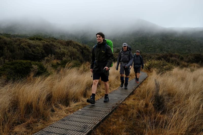
At a good 78 kilometres, the Great Walk is the longest in New Zealand. Great Walks - that's what the most important hiking trails in the country are called. And many say that the Heaphy Track is the most varied of them all.
The blessing of the prevented road
From the starting point at Brown Hut, the wide path climbs gently and evenly between mock beeches, manuka bushes and tree ferns.
Supplejack lianas twine around the branches, Maori fruit doves flutter up, birds chirp strange songs. Sometimes the forest opens up to the left, revealing the densely-forested Douglas Range and the turquoise Aorere River winding along in its gravel bed.
The Maori travelled this route between Golden Bay and the west coast 900 years ago.
The first European to walk the entire route was a gold miner named Aldridge in 1859.
The path was completed in 1893 and by then it was already 2 metres wide for oxcarts and packhorses.
The authorities spent several decades considering turning it into a motorway but thanks to protests in 1980, their plans were abandoned.
Now, this handy route is popular among hikers carrying sleeping bags, crockery and food to spend four days in the open.
If this is you, then it is worth putting your rucksack aside and taking a detour for one of the highlights of this part of the journey, and following the path up to Flanagan's Corner, the highest point of the tour at 915 metres.
Sit on the picnic bench at the summit and take a breather and survey the club lilies and jungle mountains below.
Screeching birds in front of the hut
The view from Perry Saddle Hut is just as sublime. The hut's kitchen-cum-living room is roomy and some hikers boil water to prepare their packs of freeze-dried chicken tikka masala on the gas stoves.
There's a fire in the oven, and as it gets dark outside the panoramic windows, tiny lights in the ceiling light up as if by magic - thanks to solar technology.
That is not everyone's cup of tea, however. Caroline Webb, a nurse from New Zealand's North Island, says she prefers "simple huts where you light candles in the evening."
She enjoys the trails through the wilderness she has travelled with her father and sister since childhood. For hikers from overseas, however, the hut is sufficiently basic.
"You'll definitely hear kiwis tonight," says hut warden Allen Parsons after dinner. He started the job five years ago. Every evening he listens to the national birds as they fall asleep.
Some might mistake the kiwis for the wekas that prowl around the hut. They are called marsh hens and are "clever and cheeky," says Parsons. "They steal everything in plastic bags."
Giant snails and giant birds
The next morning, most are not sure whether the kiwis sang as they are busy worrying about the dark clouds outside. It's supposed to rain for two days straight, just like back in 2003 when former prime minister Helen Clark walked the Heaphy Track. It was "truly a Great Walk," she said afterwards.
Back on the track, the drizzle makes the Gouland Downs even more atmospheric than before. With the clouds drifting low over the forest hills, the plateau recalls the Scottish Highlands. Pale clumps of tussock grass grow on the ground, along with New Zealand flax and thorny matagouri bushes.
A Powelliphanta slithers across the path, a giant snail with a shell up to nine centimetres in diameter. It eats earthworms "like spaghetti," says Parsons. To protect rare species like this, the authorities merged a patchwork of small protected areas in 1996 to form Kahurangi National Park, the second largest national park in New Zealand.
Sheltered by an umbrella, you can take in the beauty all around you. Clear streams, brown in colour from the tannin of the trees, gurgle through the savannah valleys. Round limestone rocks are reminiscent of the lion rocks of the Serengeti. All that's missing are a few moas, flightless birds which the Maori used to hunt here. But unlike the takahē, the ratites, which grew up to 4 metres, have died out.
Dangerous flash floods
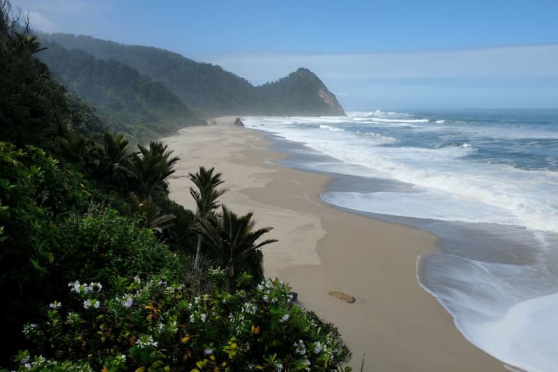
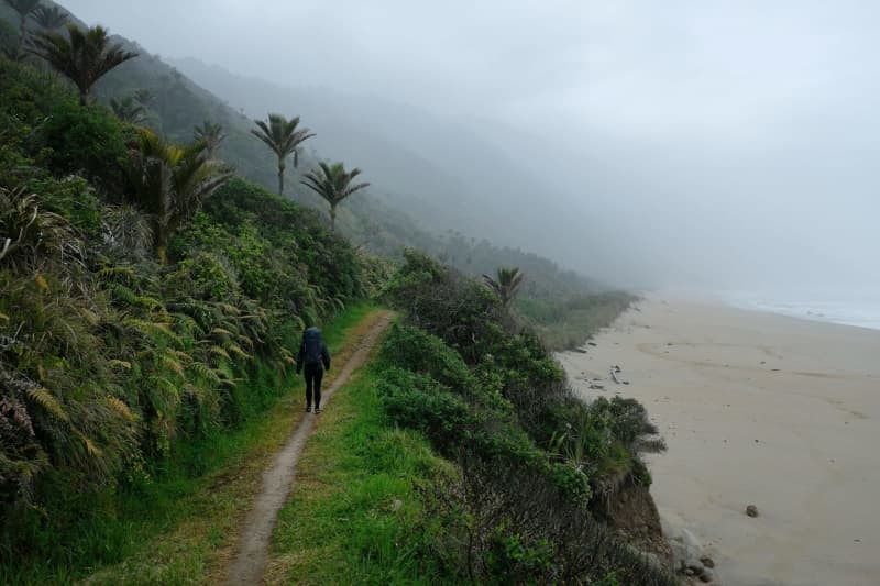
In the evening, you get a brief glimpse of the sea shining in the distance, the next destination. Descending to the coast, the forest becomes more lush and subtropical with every kilometre.
The water gurgles in small rivulets from the moss cushions at the edge of the path, the ferns and bearded lichens drip and the branches are as furry-looking as green teddy bears. Soon the first Nikau palms rise up, their curled trunks straight as candles, their fronds stretched towards the sky.
Together with the tree ferns, New Zealand's only native palms form a delicate arch. The Heaphy River shimmers in its gorge through the openings in the foliage and fronds. The Maori called it Whakapoāi - the river where the cry of the kiwi female is heard.
But it is also vulnerable to flooding. In February 2022, the river swelled so much after heavy rain that it tore away the Lewis Bridge.
As all major streams on a Great Walk must be crossed via bridges, that meant the section had to be closed. Now, two relocated and higher bridges should now be able to safely withstand even stronger flash floods as a result of climate change.
From here, the walk to the estuary is not far and you hear the waves of the rough Tasman Sea long before you see them rolling in. This is exactly where the Maori built a village in the 13th century. Archaeologists working in the 1960s found jade axes, fish hooks and rare stone cobbles, making it one of New Zealand's most important archaeological sites. Since then, however, the river has washed away two thirds of the village.
Hazy infinity by the sea
The Heaphy Hut right next door is safer. A dozen wekas peck on the lawn in front of the hut, while the wooden terrace looks out over the sea and the cliffs, overgrown with a jungle of palm trees. As magnificent as the view is, the sandflies are merciless, descending on the sweaty hikers and driving them back to their huts with their bites.
They seem to slow down as the sun sets. And the sky full of glowing cloud banks is too beautiful not to walk to the sea no matter what. A pair of paradise geese trailed by seven chicks swims past under the overhanging rocks. On the left, the wide sandy beach winds its way into the hazy infinity. One ridge after another rises behind the dunes.
It is a foretaste of the final day. Our path winds through palm forest from bay to bay. Jungle slopes veiled by wispy clouds plunge into the sea, the sand is speckled with driftwood, while spray splashes up from the rocks.
"I've never seen such a wild coastline," says Webb as she crosses the Kohaihai River on a final suspension bridge, then drops her rucksack. She says this as a New Zealander. As a guest from Central Europe, it is even more impressive.
Suggestions and practical information
The Heaphy Track is located in the north-west of New Zealand's South Island. It was created in the Kahurangi National Park, named after the British-New Zealand explorer and researcher Charles Heaphy.
Best time to travel: In New Zealand's autumn from March to May, it is no longer so warm, meaning the best conditions for hiking.
How to get there: From Christchurch, buses run to Nelson (intercity.co.nz). Buses from Golden Bay Coachlines (goldenbaycoachlines.co.nz) continue to Takaka. From there, shuttle buses (goldenbayair.co.nz) run to the starting point at Brown Hut.
Hiking: The Heaphy Track is signposted and can be walked in four days. All sleeping places in the huts must be booked online in advance. The Heaphy Track is open to mountain bikers from May to November. E-bikes are prohibited.